The NIRD project: stress-testing UK infrastructure resilience

The National Infrastructure Resilience Demonstrator (NIRD) explores how extreme weather can disrupt road networks and cause widespread economic impacts beyond direct damage. Using detailed modelling of Great Britain’s transport system, the research highlights how reliance on key routes can create vulnerabilities, with disruption to everyday journeys often driving the biggest costs. Read the full blog to explore the findings.
Some results are already integrated into the OpenCLIM tool under the Highways mapping – see What are the Impacts of Climate Change in the UK? for more details.
Introduction
The National Infrastructure Resilience Demonstrator (NIRD) project has developed an open-source modelling framework to understand how extreme weather, particularly flooding, disrupts the UK’s road network. This includes a highly detailed road transport model representing millions of road segments and connections across the country (3.3 million nodes and 3.9 million edges in Great Britain). Using this framework, the team has analysed 17 historical events (1953–2024), quantifying both direct physical damage and the wider economic impacts caused by travel disruption.
Background
A new study led by Dr Yue Li and Dr Raghav Pant at the Environmental Change Institute (ECI) in University of Oxford (also MACC Hub Partners) reveals that the biggest costs of flooding may not be road repairs, but the disruption it causes to everyday life. By combining national commuting data with detailed flood maps, the team simulated over 3 billion daily journeys across the Great Britain (GB) road network.
The analysis highlights how major cities such as London, Manchester, Glasgow and Cardiff rely on a limited number of key corridors and how disruptions to them can ripple across the wider economy. Evidence from historical GB flood events shows that the most sever disruptions are driven by large-scale connectivity loss, rather than direct asset damage alone. It also identifies overlooked weak points, including single-carriageway A-roads and suburban bridges.
The study also shows the value of using realistic flood events to test how the road network performs under stress. Instead of looking at isolated road failures, this approach captures how disruption spreads across the network – for example, how a flooded route can cause delays, rerouting and knock-on effects elsewhere. This provides a more complete picture than simpler methods, which often assess impacts in isolation. By taking this approach, the analysis moves beyond individual assets to better understand how the whole system is affected.
Integrating NIRD and OpenCLIM for the MACC Hub
Through engagement with DAFNI, the NIRD team is collaborating with the Open Climate Impacts Modelling (OpenCLIM) framework, as part of the MACC Hub to explore future climate scenarios. The aim is to better understand how travel patterns and network disruption could change under different climate and socioeconomic conditions, and what this means for vulnerability and adaptation planning. This work focuses on generating projected flow patterns and failure outcomes to support vulnerability and adaptation assessments.
OpenCLIM is an integrated assessment framework that brings together multiple models to assess climate change impacts and support decision-making on adaptations. In this work, the NIRD model includes future population scenarios to estimate how travel demand and movement patterns may change over time. These scenarios are based on the five UK-specific socio-economic pathways (SSPs): sustainability (SSP1), middle of the road (SSP2), regional rivalry (SSP3), inequality (SSP4), and fossil-fuelled development (SSP5).
Based on global SSP narratives and downscaled to the UK context, these pathways represent a range of possible future socio-economic conditions. Using SSP5 as an example, total passenger flows are projected to exceed 72 million by 2050, more than doubling the 2021 baseline level.
To assess future flood impacts, the team developed synthetic flood event maps by combining projected flood hazard data with observed historical flood footprints. The historical flood extent provides a realistic picture of where flooding is likely to occur, while the future hazard data adds information on how flood depths may change under climate change. These datasets were then adjusted so they could be used at a consistent level of detail, producing realistic future versions of past flood events under changing climate conditions.
Results
Using these climate and flow projections, the NIRD framework was then used to stress-test the national road network under future commuting demand. The results show that:
(1) By 2050, commuting flows are expected to become more concentrated along major inter-urban corridors including key North–South routes (M1, M5, M6) and East–West links (M4, M62/A66, M8). This pattern reflects the strong reliance of dense urban labour markets on a limited number of key routes and interchanges, which in turn increases overall system vulnerability under future demand pressures (Figure 1).
(2) Climate change intensifies transport disruption, with impacts becoming more widespread and (Figure 2) and more frequently reaching moderate to high severity along key inter-urban corridors.
(3) Across both current and future scenarios, indirect economic. make up the majority of total impacts. Under future conditions, indirect losses increase significantly even when direct damage changes only slightly, with impacts rising by up to an order of magnitude in some events due to higher travel demand (Figure 3).
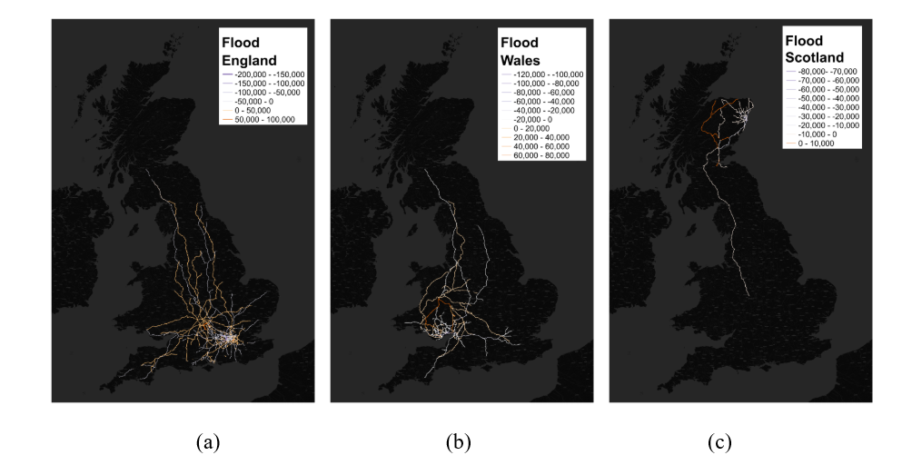
(4) Of the indirect impacts, disruption caused by rerouting is generally greater than that caused by isolation. However, Scotland’s connections to the rest of Great Britain are a notable exception, where limited alternative routes create critical single points of failure for travel in and out of Scotland.
Figure 1. Spatial commuting flows comparison (left: baseline, 2021; right: future, 2050, SSP5).
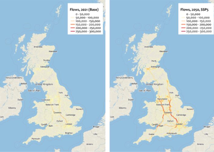
Figure 2. Road damage composition changes (including no damage, minor, moderate, extensive and severe) between baseline and future climate scenarios.
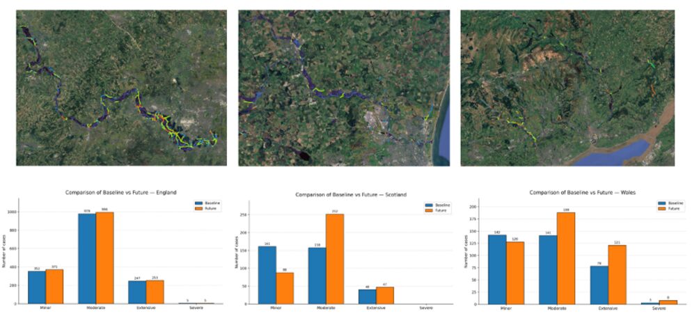
Figure 3. Comparing direct damage, rerouting-related and isolation-related losses between (a) baseline scenario (2021) and (b) future climate change scenario (SSP5, 2050).
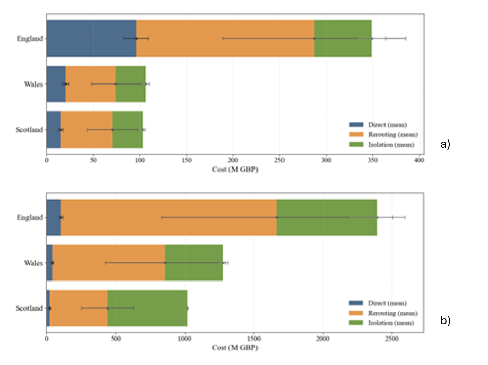
Figure 4. Spatial flow changes (orange: increase, purple: decrease) due to flood disruption and passenger rerouting decision caused by three synthetic flood events in England, Wales and Scotland (from left to right).
Reflection
Overall, the network is relatively resilient across England and Wales under flood conditions. However, connections between Scotland and the rest of Great Britain emerge as a key vulnerability under future flood risk.
From a resilience and adaptation perspective, these findings suggest that smaller or less connected parts of the network may be more sensitive to climate impacts.. This highlights the importance of prioritising key corridors, strengthening network redundancy, and embedding climate risk into long-term infrastructure planning.
Further reading and tools
Li, Y., Pant, R., Russell, T., Thomas, F., Hall, J.W., Oldham, P., Lamb, R. and Young, P.J. (2026) Stress-testing road network resilience using counterfactual flood events (1953–2024) in Great Britain. Transportation Research Part D: Transport and Environment. https://doi.org/10.1016/j.trd.2026.100854
Partial results have been integrated into the MACC HUB platform – What are the Impacts of Climate Change in the UK? Click this link for more details.
Further resources

Building a Climate-Resilient City: Transportation infrastructure

Comments
There is no contentYou must be logged in to reply.